


Parque Rural de Anaga
EUROPE'S OLDEST FOREST. UNESCO Biosphere Reserve with the HIGHEST CONCENTRATION OF ENDEMIC SPECIES per km² in all of Europe. 40-million-year-old laurel forest - a living fossil. Vertigo viewpoints, wild black beaches, lost villages in ravines. 10+ PHOTO SPOTS that will blow up your camera. FREE. 15 minutes from La Laguna. SAME ROUTE as Playa de Las Teresitas → La Laguna → Anaga = perfect northeast day.
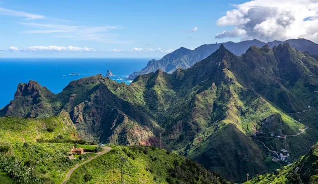
Parque Rural de Anaga occupies the north-eastern massif of Tenerife - geologically the oldest part of the island (7-9 million years). UNESCO Biosphere Reserve since 2015, with the highest density of endemic species per km2 in all of Europe. The treasure: laurisilva (laurel forest) - a subtropical ecosystem that covered the Mediterranean 40 million years ago and survived here thanks to trade winds creating a permanent humid microclimate.
WHAT YOU'LL SEE: Mountains cloaked in laurel forest with twisted moss-covered trunks. Giant ferns. Mist seeping through the canopy. Deep ravines dropping to the sea forming beaches of black volcanic sand. Villages with white houses clinging to impossible slopes. Viewpoints with views across the Atlantic and to Teide. Roads carved into rock. Like Jurassic Park crossed with Tolkien.
THE PERFECT TRIANGLE - SAME ROUTE: La Laguna (UNESCO) + Anaga (Biosphere) + Las Teresitas (beach) lie on ONE route. The best day in north-east Tenerife without retracing your steps.
FROM LA LAGUNA: TF-12 towards Las Mercedes → Cruz del Carmen (15 min, first viewpoint). Continue TF-12 to El Bailadero → descend to Taganana/Benijo. FROM SANTA CRUZ / LAS TERESITAS: climb via San Andrés → TF-12 to the ridges. FROM THE SOUTH: TF-1 → TF-5 → La Laguna → TF-12. ~1h15 to Cruz del Carmen.
TITSA lines 945 and 947 from Santa Cruz enter Anaga. Line 946 to Taganana/Benijo. Limited frequency - car highly recommended.
Get here by busFREE parking at Cruz del Carmen (large), Pico del Inglés (limited), and various points along TF-12. Taganana and Benijo: limited parking, in high season arrive early. Summer weekends Cruz del Carmen can fill up - go early.
Navigate to parkingSendero de los Sentidos
1.3 km easy loop through ancient laurel forest from Cruz del Carmen. Twisted moss-covered trunks, giant ferns, filtered light. Known as the 'Hobbit Forest'. Best in fog - the magic intensifies.
El Pijaral - Enchanted Forest
8.7 km through the most pristine laurel forest in Tenerife (3-4h, moderate). FREE permit required - max 45 people/day. Book on TenerifeON up to 14 days ahead, slots released every Monday at 07:00. Fine of 600 EUR without permit.
Roque de Taborno - Tenerife's Matterhorn
4 km circular trail around a dramatic basalt spire (2-2.5h, moderate). Exposed ridgelines, coastal views, steep drops. Not for those afraid of heights. Starts at Taborno village chapel. Limited parking - arrive early.
Mirador Pico del Ingles
At ~990 m - 360 degree panorama: Santa Cruz, Teide, Roques de Anaga, Atlantic coastline. One of the best viewpoints on the island. Best early morning for clear Teide views.
Navigate here↗Mirador Cruz del Carmen
Starting point for Sendero de los Sentidos and main Anaga hub. Clear day: La Laguna + Teide. Misty day: laurel forest like Lord of the Rings. Both spectacular.
Navigate here↗Mirador de Jardina
First panorama on the TF-12 entering Anaga: La Laguna spread below, Teide on the horizon. Local woman usually sells bollos here.
Navigate here↗Playa de Benijo
The most iconic wild beach in northern Tenerife. Black volcanic sand, Roques de Anaga rock pillars rising from the sea, crashing waves. Arrive 1h before sunset for the shot. Strong currents - swimming with caution.
Navigate here↗Taganana
White village in a ravine dropping to the sea, accessible via the spectacular TF-134 descent. Best fresh fish restaurants in Anaga. The drive down with the village revealed below is a photo spot in itself.
Navigate here↗Chinamada - Cave Houses
Inhabited village where people live in caves carved into the rock cliff, with terraces overlooking the Atlantic. Surreal: cave houses with satellite dishes. Reach via trail from Punta del Hidalgo (~2h) or by car.
Navigate here↗INSIDER TIPS:
1. FOG IS YOUR FRIEND: If you arrive and it's foggy, DON'T be disappointed. Misty days are when the laurisilva shows its true magic - trees wrapped in mist, filtered light, glistening moss. Sendero de los Sentidos in fog is a SUPERNATURAL experience.
2. THE PERFECT TRIANGLE - SAME ROUTE: La Laguna + Anaga + Las Teresitas are on ONE route. Ideal plan: 9:00 La Laguna UNESCO centre - 11:00 Anaga miradores + Sendero de los Sentidos - 12:30 Pico del Ingles + Camino Viejo - 13:30 Taganana lunch - 15:00 Benijo - 16:30 Las Teresitas sunset. EPIC DAY without retracing.
3. MORNINGS FOR MIRADORES: Fog usually covers the peaks in the afternoon (trade wind effect). For panoramic views with Teide visible: early morning. For mystical forest photos: afternoon with fog.
4. NARROW ROADS - PATIENCE: Anaga roads are NARROW with sharp bends. Drive slowly, honk on blind corners, yield to oncoming traffic.
5. GEAR UP: Bring a jacket/waterproof (constant humidity, rain possible!). Good shoes. Water and snacks. Charged phone. Full tank (no stations in the park!).
6. COMBINE WITH BAJAMAR / PUNTA DEL HIDALGO: Descending the north side to Tejina/Bajamar (TF-13) you can combine Anaga with the natural pools of Bajamar and Punta del Hidalgo.
The Anaga Massif is Tenerife's oldest geological formation, between 7 and 9 million years old. It occupies the island's northeast tip, spanning 14,500 hectares across the municipalities of Santa Cruz de Tenerife, San Cristóbal de La Laguna and Tegueste. Declared a UNESCO Biosphere Reserve on 9 June 2015, recognising its extraordinary biodiversity - it hosts the highest concentration of endemic species per square kilometre in all of Europe.
Its greatest treasure is the laurisilva (laurel forest), a subtropical ecosystem that covered the Mediterranean basin 40 million years ago (Tertiary era). Glaciers swept these forests from mainland Europe, but they survived on the Macaronesian islands (Canaries, Madeira, Azores) thanks to the trade winds. Anaga is one of the last refuges of this 'living fossil'.
The massif harbours nearly a hundred unique invertebrate species, emblematic birds such as the Bolle's pigeon and the laurel pigeon (Canary Islands endemics), and rich marine life. 26 hamlets maintain some 2,000 inhabitants. The Guanches inhabited these ravines, leaving archaeological remains. After the Castilian conquest (15th century), settlers established in valleys like Taganana (16th-century church). The TF-12 road built in the 20th century made the park more accessible.
PHOTOGRAPHER'S ROUTE - NORTHEAST TRIANGLE (full day):
9:00 - LA LAGUNA historic centre (UNESCO) 10:30 - TF-12 towards Anaga → Mirador de Jardina (5 min stop) 10:50 - Cruz del Carmen → Sendero de los Sentidos (30-60 min, laurel forest) 11:45 - Pico del Inglés → Mirador (360° panorama) + Camino Viejo (THE Instagram spot, ~15 min) 12:30 - TF-12 → El Bailadero → TF-134 descent to Taganana (photo of village from above) 13:00 - Lunch in Taganana (fresh fish) 14:30 - Continue to Almáciga → Benijo (viewpoint + beach) 15:30 - Return via Taganana → El Bailadero → San Andrés 16:30 - PLAYA DE LAS TERESITAS (swim + aerial viewpoint) 17:30-18:00 - Sunset from Las Teresitas 18:30 - Return to hotel
QUICK ALTERNATIVE (half day): La Laguna → Mirador Jardina → Cruz del Carmen (Sendero Sentidos) → Pico del Inglés (Camino Viejo) → return. 3-4 hours.
Camino Viejo al Pico del Inglés - old road carved in rock, moss-covered walls, branches intertwining overhead. THE MOST FAMOUS Instagram spot of Anaga.
Camino Viejo al Pico del Inglés - old road cut through rock, walls covered in moss, branches intertwining to form a tunnel. THE most Instagrammed spot in Anaga. 10 min walk from the road. Most magical in fog.
Roque de las Ánimas - monumental rock pinnacle visible from the viewpoints above Taganana.
Roque de las Ánimas - monumental rock pillar visible from viewpoints above Taganana. Icon of Anaga's wild coastline.